UAV Communications
Unmanned aerial vehicles (UAVs) have attracted significant attention as flexible and cost-effective platforms for wireless communication, sensing, and data collection. Leveraging their high mobility and three-dimensional deployment capability, UAVs can support communicationand localization in disaster areas, large-scale events, and infrastructure-limited environments.
Our research investigates UAV communication systems covering trajectory optimization, UAV networking, localization, and integration with satellite and aerial platforms.
UAV Networking and Trajectory Optimization
We constructed a smart agriculture education and research field at the Suzukakedai campus. A new field server and a stable power supply network were deployed to enable two-way communication in an off-grid environment.
By leveraging LEO satellite communication, including STARLINK mini, the system supports continuous sensing and remote operation. Using the collected data, we designed an automatic tractor operation system, demonstrating the feasibility of smart agriculture in infrastructure-limited environments.
Fig.12 Three-dimensional UAV trajectory for efficient data collection.
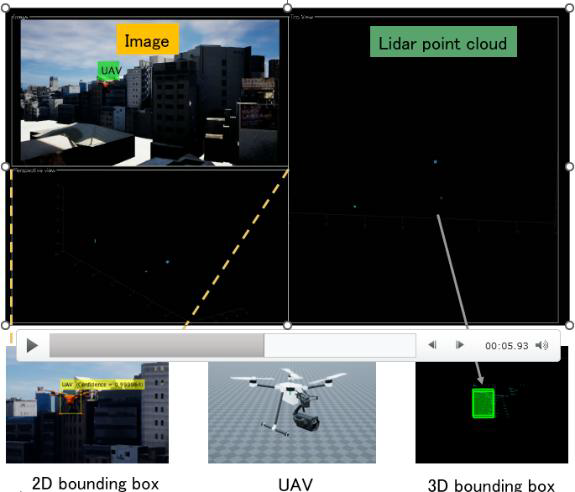
Fig.13 UAV detection using image and LiDAR sensors for UAV-to-UAV communication.
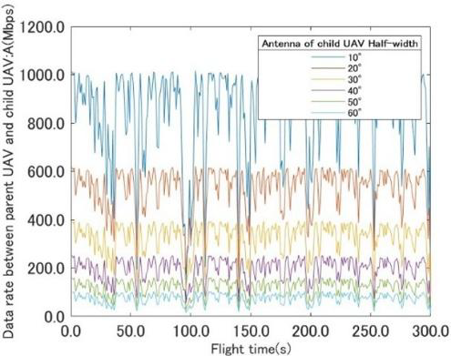
Fig.14 Data rate trends between UAVs under different antenna configurations.
Localization Using UAVs and High-Altitude Platforms
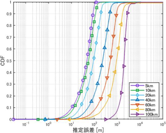
We investigate localization techniques using aerial platforms to detect and estimate the positions of radio wave sources. Using high-altitude platform stations (HAPS), we propose a radio source localization system that achieves high positioning accuracy even under non-line-of-sight conditions.
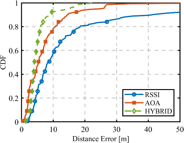
In addition, we develop a UAV-based localization method that combines received signal strength indicator (RSSI) and angle-of-arrival (AOA) measurements. Simulation results demonstrate that the hybrid approach significantly outperforms single-signal-based methods.
Fig.15 CDF of localization accuracy using HAPS-based radio source estimation.
Fig.16 CDF of distance error comparing RSSI, AOA, and hybrid localization methods.
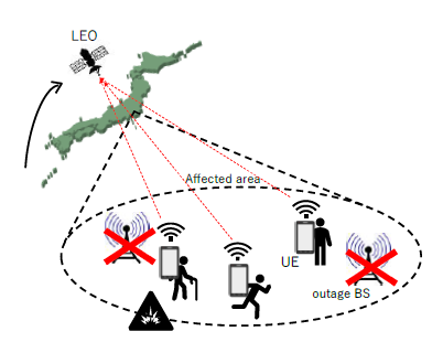
UAV and LEO-Based Systems for Disaster Response
To support rapid rescue operations in disaster-prone regions, we propose a population distribution estimation system using low Earth orbit (LEO) satellites. The system enables large-area estimation without relying on terrestrial infrastructure and contributes to disaster response planning and congestion analysis.
The feasibility of the proposed system is verified through simulation studies, demonstrating the potential of integrating UAVs and satellite systems for emergency communications.
Fig.17 Population distribution estimation using LEO satellite-based systems.